


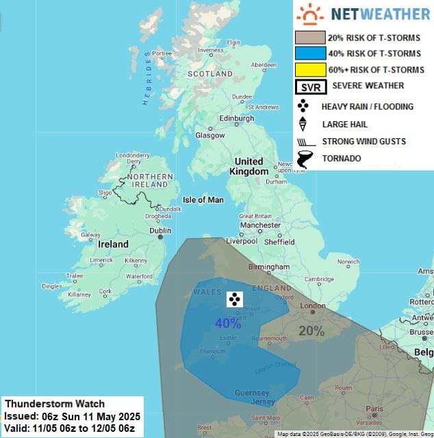
The UK is bracing for a period of unsettled weather as thunderstorms are expected to sweep across the south and west regions.


This change in weather comes after a dry spell, with forecasts indicating a potential stormy break in the weather pattern. The UK weather forecast suggests that high pressure will become re-established, leading to more settled conditions.
Residents in South Wales and the West Midlands should be prepared for the possibility of thunderstorms this weekend, according to the latest UK weather update.
Key Takeaways
- Thunderstorms expected in the south and west UK regions.
- A dry spell is anticipated to be interrupted by stormy weather.
- High pressure to bring settled conditions next week.
- South Wales and West Midlands to be affected by thunderstorms.
- Latest UK weather forecast indicates a change in weather pattern.
Spring’s Unusual Dry Spell Across the UK
Spring in the UK has been marked by a notable lack of rainfall, leading to a dry spell with far-reaching consequences. This unusual dry spell has raised concerns among farmers, gardeners, and water resource managers.
Record-Breaking Dry Conditions and Their Causes
The dry conditions this spring have been record-breaking in many parts of the UK. March was particularly dry for most regions, with only Scotland recording more than half of the average rainfall.
Comparison to Historical Spring Weather Patterns
Historically, spring seasons with such low rainfall have been rare. The current dry spell is among the top five driest springs recorded in the past few decades.
Meteorological Factors Behind the Dry Spell
A high-pressure system dominating the UK’s weather pattern is a significant factor behind the dry spell. This system has blocked the usual spring rainfall.
Effects on Agriculture, Gardens, and Water Resources
The dry spell has significant implications for agriculture, gardens, and water resources. Farmers are facing challenges in maintaining crop health, while gardeners are struggling to keep plants hydrated.
Farming Challenges During Extended Dry Periods
Farmers are experiencing reduced crop yields and are having to irrigate more frequently, increasing costs.
Water Conservation Measures Being Implemented
To mitigate the effects of the dry spell, water conservation measures are being implemented. These include restrictions on water usage for non-essential activities.
| Region | Rainfall Deficit | Impact on Agriculture |
|---|---|---|
| South East England | 60% below average | Significant yield reduction |
| South West England | 50% below average | Moderate impact |
| Scotland | 20% below average | Minimal impact |
Showers Move Into the South and West Before Settled Conditions Prevail Next Week
As we head into the weekend, the south and west parts of the UK are bracing for showers and unsettled weather. A significant change in the weather outlook is anticipated, with an increasing chance of rain, showers, and isolated thunderstorms moving northwards across the southwest of the UK on Saturday night.

Detailed Timeline of Approaching Weather Systems
The weather systems are expected to evolve significantly over the next 48 hours. Here’s a breakdown of the expected changes:
Frontal Systems Moving Across the Atlantic
A frontal system is moving across the Atlantic, bringing with it a mass of rain and showers. This system is expected to reach the southwest of the UK on Saturday night, leading to a deterioration in weather conditions.
Hour-by-Hour Breakdown of Expected Changes
The weather is expected to change rapidly over the weekend. Here’s an hour-by-hour breakdown:
- Early Saturday: Mostly dry with some sunshine
- Late Saturday: Increasing cloud and showers
- Saturday Night: Rain and thunderstorms moving northwards across the southwest
- Sunday: Showers and bright intervals across the south and west
Regional Variations in Weather Patterns
The weather patterns are expected to vary significantly across different regions of the UK.

Northern vs. Southern UK Weather Divide
The north-south divide in weather patterns is expected to be pronounced, with the north remaining relatively dry and the south experiencing showers and thunderstorms.
Coastal Areas vs. Inland Weather Differences
Coastal areas are likely to experience more unsettled weather compared to inland areas, with a higher chance of showers and strong winds.
As the weather systems continue to evolve, it’s essential to stay updated with the latest uk weather forecast to plan your activities accordingly. The settled conditions expected next week will be a welcome relief after the unsettled weather.
Thunderstorm Alert: Areas Most at Risk This Weekend
A fresh wave of thunderstorms is set to sweep across parts of the UK, with the West Country, South Wales, and West Midlands being the most affected areas. As meteorologists warn of the impending storm, residents are advised to prepare for potential disruptions.
“We’re expecting a significant change in weather this weekend, with thunderstorms likely to cause some issues,” said a spokesperson for the Met Office. The weather front is expected to bring heavy rain and strong winds to the affected regions.
West Country Facing Significant Storm Activity
The West Country is one of the areas most at risk, with storms expected to hit Cornwall and Devon. Residents in these areas should be prepared for heavy rainfall and potential flooding.
Cornwall and Devon Storm Timing and Intensity
The storms are expected to hit Cornwall and Devon on Sunday, with the worst of the weather expected during the late morning and early afternoon. The Met Office has issued a yellow warning for the area, indicating a moderate risk of severe weather.
Historical Context of Spring Storms in the Region
Spring storms are not uncommon in the West Country, with the region experiencing several significant storms in recent years. As
“the region’s geography makes it prone to such weather events,”
said a local weather expert. Historical records show that the area has been affected by severe storms during the spring months, causing disruptions and damage.
South Wales Weather Warnings and Preparations
South Wales is another area that is expected to be affected by the storms, with Cardiff and coastal areas being particularly vulnerable. The local authorities are working to ensure that they are prepared for any potential issues.
Cardiff and Coastal Areas Storm Forecast
The storms are expected to hit South Wales on Sunday, with heavy rain and strong winds forecasted. Residents are advised to be cautious and to follow the advice of the local authorities.
Local Authority Response Measures
The local authorities in South Wales are taking steps to prepare for the storms, including clearing drains and checking flood defenses. As Rhianon Passmore, the council leader, said, “we are working closely with the Met Office and other agencies to ensure that we are prepared for any potential issues.”
West Midlands Storm Predictions and Alerts
The West Midlands is also expected to be affected by the storms, with Birmingham and surrounding areas being at risk. The Met Office has issued a yellow warning for the area, indicating a moderate risk of severe weather.
Birmingham and Surrounding Areas Weather Outlook
The storms are expected to hit the West Midlands on Sunday, with heavy rain and strong winds forecasted. Residents are advised to be cautious and to follow the advice of the local authorities.
Met Office Warning Levels Explained
The Met Office uses a system of warning levels to indicate the severity of the weather. A yellow warning indicates a moderate risk of severe weather, while amber and red warnings indicate more severe risks. As the Met Office said, “we issue warnings based on the potential impact of the weather, rather than just the weather itself.”
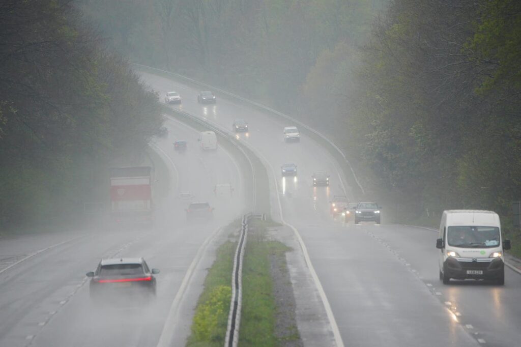
Severe Weather Conditions: What Residents Should Prepare For
Severe weather conditions are expected to affect the UK, particularly the South and West, with heavy rainfall and potential disruptions. Residents in these areas should be prepared for the impacts of severe weather, including heavy rainfall, hail, lightning, and localized flooding.

Heavy Rainfall Projections and Potential Impacts
Heavy rainfall is forecasted to hit certain areas of the UK, with amounts potentially reaching 20-40mm in brief periods. This could lead to localized surface water flooding, particularly in areas with poor drainage.
Expected Rainfall Amounts: 20-40mm in Brief Periods
Some areas may experience heavy rainfall at a rate of 20-40mm in a few hours, which can cause significant surface water flooding. Residents should be prepared for rapid changes in weather conditions.
Urban vs. Rural Area Rainfall Effects
The impact of heavy rainfall can vary between urban and rural areas. Urban areas with more hard surfaces and complex drainage systems may experience more rapid flooding, while rural areas might see more widespread flooding due to the terrain.
Hail and Lightning Risks Across Affected Regions
Apart from heavy rainfall, there is also a risk of hail and lightning across the affected regions. These conditions can pose significant risks to people outdoors and cause damage to property.
Lightning Strike Safety Precautions
Residents should take precautions during lightning storms, such as staying indoors, avoiding conductive objects, and not using electrical appliances. It’s essential to monitor weather updates for lightning warnings.
Hail Size Predictions and Potential Damage
Hail size predictions indicate that some areas may experience hail large enough to cause damage to vehicles and property. Residents should secure outdoor items that could become projectiles in strong winds or hail.
Localized Flooding Concerns and Vulnerable Areas
Localized flooding is a significant concern during severe weather events. Areas with a history of flooding or poor drainage are particularly vulnerable.
Flood-Prone Regions on High Alert
Regions known to be prone to flooding are on high alert during severe weather conditions. Residents in these areas should be prepared to take action if necessary, including moving to higher ground or following evacuation instructions.
Drainage System Preparedness in Urban Centers
Urban centers need to ensure their drainage systems are prepared for heavy rainfall. Maintenance of drains and gullies is crucial to prevent flooding in these areas.
From Sunshine to Storms: Weekend Temperature Rollercoaster
As the weekend approaches, the UK is set to witness a wild swing in temperatures, transitioning from warm, sunny conditions to stormy weather.
Weekend Highs Reaching 25-26°C Before Storm Arrival
The weekend is expected to start on a warm note, with temperatures soaring to highs of 25-26°C in many parts of the country. Specifically, eastern Wales, the Midlands, East Anglia, and the south of England are forecasted to experience highs of around 24°C.
Saturday’s Peak Temperatures by Region
Regional variations will be noticeable on Saturday, with the southern regions expected to be particularly warm. The east of England will also experience high temperatures, making it a pleasant start to the weekend for many.
Heat-Related Health Advice for Vulnerable Groups
It’s essential for vulnerable groups, such as the elderly and young children, to take necessary precautions during the heatwave. Staying hydrated and avoiding strenuous activities during the peak heat are highly recommended.
Post-Storm Temperature Drops and Weather Shift
Following the storm arrival, temperatures are expected to drop significantly, bringing an end to the warm spell. This shift will be quite dramatic, with temperatures plummeting as the storm systems move across the country.
Sunday Evening and Monday Morning Temperature Forecast
By Sunday evening and into Monday morning, temperatures are expected to have dropped substantially, reflecting the change in weather patterns. The cooler air will bring relief from the heat but also signals a return to more unsettled weather.
How Storm Systems Affect Local Temperatures
Storm systems have a profound effect on local temperatures, often causing significant drops as the cooler air masses associated with these systems move into an area. Understanding this can help in preparing for the temperature fluctuations.
Staying Safe During Severe Weather Events
With thunderstorms forecasted to hit the South and West regions, staying safe during severe weather is a top priority. As the weather conditions deteriorate, residents in these areas need to be prepared for potential hazards.

Essential Driving Tips for Motorists During Sudden Downpours
Motorists are advised to exercise caution due to the potential for sudden downpours. Driving safely during such conditions requires attention to several key factors.
Visibility Challenges and Headlight Usage
During heavy rainfall, visibility is significantly reduced. Using headlights can help increase your vehicle’s visibility to other drivers, although it’s crucial to avoid dazzling other road users with high beams.
Avoiding Flooded Roads and Hydroplaning Risks
Flooded roads pose a significant risk, including the danger of hydroplaning, where tires lose contact with the road surface. To avoid this, drivers should reduce speed and steer clear of flooded areas.
Home and Property Protection Measures
In addition to driving safely, protecting homes and properties from storm damage is essential. There are several steps residents can take to minimize potential damage.
Securing Outdoor Items Before Storms Arrive
Outdoor items such as garden furniture and bins can become projectiles in strong winds. Securing these items before the storm hits can prevent damage to windows and roofs.
Checking Drainage Systems to Prevent Water Damage
Clearing drainage systems and ensuring that gutters are free from debris can help prevent water from accumulating around homes, thereby reducing the risk of water damage.
By following these tips, residents can significantly reduce the risks associated with severe weather events. Staying informed and prepared is key to navigating through such conditions safely.
Arctic and Antarctic Updates: Polar Weather Influencing Global Patterns
The Arctic and Antarctic regions are experiencing significant changes that are influencing global weather patterns. Recent observations and research findings from these polar regions are providing insights into how they are impacting our climate.
Recent Arctic Climate Observations and Anomalies
The Arctic region has been experiencing notable climate anomalies, with significant implications for global weather trends. Some of the key observations include:
- Rapid changes in sea ice extent
- Temperature trends that are diverging from global averages
- The impact of the Arctic Oscillation on European weather patterns
Sea Ice Extent and Temperature Trends
Recent data shows that the Arctic is experiencing a decline in sea ice extent, with some months recording historic lows. This decline is closely linked to rising temperatures in the region, which are occurring at a rate faster than the global average.
Arctic Oscillation Effects on European Weather
The Arctic Oscillation (AO) has a significant impact on weather patterns across Europe. Recent trends in the AO have led to unusual weather events in various parts of the continent, including colder winters and warmer summers. Understanding the AO’s behavior is crucial for predicting European weather patterns.
Antarctic Weather Developments and Research Findings
Meanwhile, in the Antarctic, researchers are monitoring weather developments that are having a significant impact on the Southern Hemisphere’s climate. Recent scientific expeditions have uncovered new insights into the region’s weather patterns and their global implications.
Recent Scientific Expeditions and Discoveries
Recent expeditions to Antarctica have led to several key discoveries, including new insights into the region’s ice sheets and oceanic circulation patterns. These findings are crucial for understanding the Antarctic’s role in global climate trends.
Antarctic Influence on Southern Hemisphere Weather Systems
The Antarctic plays a significant role in shaping weather systems across the Southern Hemisphere. Changes in the Antarctic climate can have a ripple effect, influencing weather patterns in Southern Africa, Australia, and South America. Research is ongoing to better understand these connections.
Looking Ahead: Return to Settled Weather Next Week
After a tumultuous few days, the UK is set to enjoy a return to settled weather next week. Following a period of unsettling storms and variable conditions, many parts of the country are forecast to experience a more stable and pleasant weather pattern.
Much of the UK will have another bright sunny day on Tuesday, with settled conditions covering the vast majority of the UK by Wednesday. This shift will bring a welcome change for many regions, offering a chance to enjoy the outdoors without the disruptions caused by recent weather events.
Temperature and Sunshine Outlook Across UK Regions
The temperature outlook for next week indicates a gradual rise in temperatures across the UK, with some regions expected to enjoy sunshine and mild conditions. This will be a welcome respite after the recent storms.
London and Southeast England Forecast
London and the Southeast are expected to experience a rise in temperatures, reaching the mid-teens by the end of the week. This will be accompanied by a significant amount of sunshine, making it a good time for outdoor activities.
Scotland, Wales, and Northern Ireland Weather Prospects
Scotland, Wales, and Northern Ireland will also see an improvement in weather conditions, with a decrease in rainfall and an increase in sunshine. While temperatures will be slightly cooler than in the Southeast, the overall trend is toward more settled weather.

Long-range Forecast for Late Spring into Early Summer
Looking beyond next week, the long-range forecast suggests that the trend toward more settled weather will continue into late spring and early summer. This could mean a pleasant period for the UK, with temperatures gradually rising.
Potential Weather Patterns Through June
As we move into June, there are indications that the UK might experience a more consistent weather pattern, with less variability than we’ve seen in recent months. This could be a welcome change for many, allowing for better planning of outdoor activities and events.
Comparison to Typical Late Spring Conditions
Compared to typical late spring conditions, the forecast suggests that the UK might experience a slightly warmer than average period. This will be a welcome change for many, as it will allow for a gentle transition into summer.
Conclusion: Navigating the UK’s Changeable Spring Weather
The UK’s spring weather is proving to be as unpredictable as ever, with a mix of sunshine, storms, and eventually settled conditions expected in the coming days. As discussed, a dry spell has been followed by thunderstorms hitting the south and west regions, with severe weather conditions posing risks to residents.
To navigate this changeable uk spring weather, it’s essential to stay informed about the latest weather updates and forecasts. With temperature fluctuations and potential localized flooding, being prepared is key. The return to settled weather next week will bring a welcome respite from the storms.
By understanding the uk spring weather patterns and staying up-to-date with the latest navigating weather updates, individuals can better plan their daily activities and stay safe during severe weather events. As the UK continues to experience changeable weather, staying informed will be crucial in making the most of the spring season.
FAQ
Will the UK have storms this weekend?
Yes, the UK is expected to experience thunderstorms in the south and west regions this weekend before the weather settles next week.
How to drive safely in thunderstorms in the UK?
To drive safely, slow down, use low gear, avoid flooded areas, and keep a safe distance from other vehicles. It’s also essential to check the weather forecast and Met Office weather alerts before embarking on a journey.
Is there a flood warning near me?
To check for flood warnings in your area, visit the Met Office or Environment Agency website, or check local news and weather reports for updates on localized flooding concerns and vulnerable areas.
What is the UK weather forecast for next week?
The UK weather is expected to settle next week, with a return to more stable conditions. The temperature and sunshine outlook vary across regions, but overall, it’s expected to be more pleasant.
How can I protect my home and property from storm damage?
To protect your home and property, secure loose outdoor items, trim trees, and clear drains. You can also consider installing storm shutters or impact-resistant windows to minimize potential damage.
What are the latest Arctic and Antarctic weather updates?
Recent climate observations and anomalies in the Arctic and Antarctic regions are influencing global weather patterns. For the latest updates, check the Met Office or research institutions for the most current information.
Will the UK experience a heatwave in 2024?
While there’s no definitive forecast for a heatwave in 2024, the UK is experiencing temperature fluctuations. Stay updated with the latest weather forecasts and Met Office alerts for any potential heatwaves or temperature changes.
What are the safety tips for sudden downpours in the UK?
During sudden downpours, avoid driving or walking through flooded areas, and be cautious of potential flash flooding. Stay informed about weather conditions, and follow evacuation instructions if necessary.
What is the pollen count like after rain in the UK?
After rain, the pollen count typically decreases as the rain washes away pollen from the air. However, it’s essential to check local pollen forecasts for the most up-to-date information.
When will the rain stop in the UK?
The rain is expected to clear by next week, with a return to more settled weather conditions. Check the latest weather forecasts for specific regional updates.


