


A powerful storm system has brought severe weather to the region, with a reported tornado near Bennett and Watkins along I-70 east of Denver.


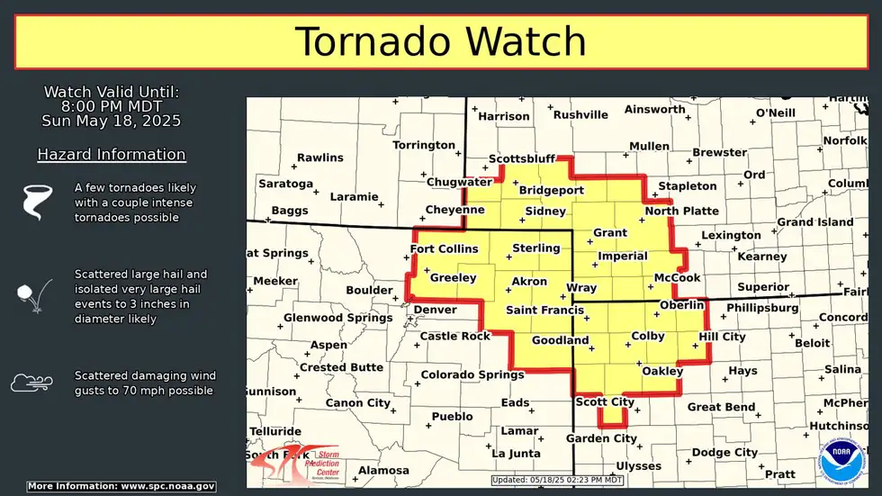
The Storm Prediction Center has issued a tornado watch for southwestern Kansas and western Oklahoma, indicating a potential for EF3 or stronger tornadoes. Residents are advised to be cautious of large hail up to 3 inches in diameter and damaging winds gusting up to 70 mph.
The latest updates from the National Weather Service and Storm Prediction Center will be crucial in understanding the progression of this severe weather event.
Key Takeaways
- A tornado was reported near Bennett and Watkins along I-70.
- A tornado watch has been issued for southwestern Kansas and western Oklahoma.
- Residents should be cautious of large hail and damaging winds.
- The Storm Prediction Center is closely monitoring the situation.
- Updates from the National Weather Service are crucial for understanding the weather event.

Breaking News: Tornado Touches Down Near Bennett/Watkins Area
A powerful tornado has touched down near the Bennett/Watkins area, prompting immediate action from local authorities and weather services. The situation is critical, with multiple warnings issued for the surrounding regions.
Immediate Threat Assessment
The immediate threat assessment indicates a significant risk from large hail (3″) and 70+ MPH winds, which can cause substantial damage to structures and vehicles. Residents are advised to be prepared for potentially deadly flying debris.
Large Hail (3″) Potential
The potential for large hail up to 3 inches in diameter poses a significant threat to property, including vehicles and buildings. Hail of this size can cause severe damage, including shattered windows and dented roofs.
70+ MPH Wind Threats
Winds exceeding 70 MPH can lead to further destruction, including downed trees and power lines. The combination of large hail and strong winds exacerbates the risk of injury and property damage.
Current Weather Alerts
The National Weather Service has issued multiple tornado warnings across various counties, including Arapahoe, Bennett, and Adams. The current weather alerts indicate a significant threat from intense tornadoes.
Tornado Watch Status
A tornado watch remains in effect for southwestern Kansas and western Oklahoma, highlighting the potential for intense tornadoes in these regions. Residents are advised to remain vigilant and prepared to seek shelter at a moment’s notice.
Severe Thunderstorm Warnings
Severe thunderstorm warnings have been issued for areas affected by the tornado, indicating a risk of damaging winds and large hail. The warnings underscore the need for continued caution and preparedness.
The situation near Bennett and Watkins is being closely monitored, with updates provided as more information becomes available. Residents are urged to stay informed through reliable weather information sources and to follow evacuation instructions from local authorities.
Live Storm Updates: Denver Tornado Situation Developing
Live updates on the Denver tornado indicate a potentially severe weather event unfolding near Bennett and Watkins. Residents in the affected areas are advised to stay informed and follow the latest updates from local weather authorities.
4:38 PM EDT: High-Risk Tornado Zones Identified
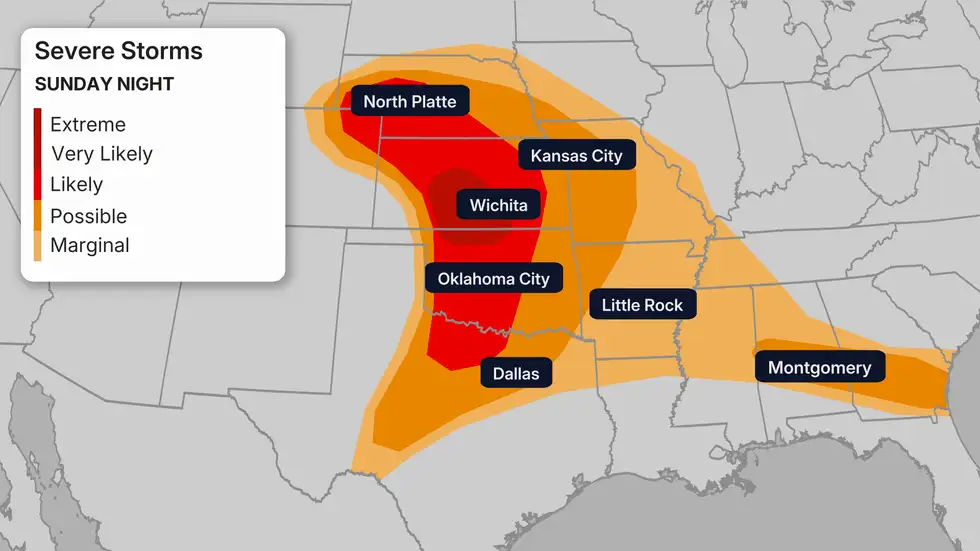
At 4:38 PM EDT, the Storm Prediction Center (SPC) identified high-risk tornado zones, indicating areas of severe concern. The SPC’s outlook highlighted regions in red, signifying the highest risk for tornadoes. This critical information helps residents and authorities prepare for the potential impacts.

4:26 PM EDT: First Damage Reports from Bennett/Watkins
The first damage reports from the Bennett and Watkins areas were received at 4:26 PM EDT. Visuals from the affected regions show the impact of the severe weather, with reports indicating potential structural damage. The extent of the damage is still being assessed, and residents are urged to exercise caution.
Earlier Storm Development
The storm system that led to the Denver tornado situation has been developing throughout the day. Understanding the progression of the storm is crucial for assessing the ongoing risks.

Storm Prediction Center Alerts
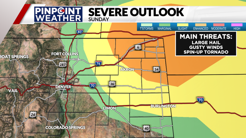
The SPC issued a Level 3/5 severe risk for the northeastern Colorado plains, indicating a significant threat from severe weather. The SPC’s alerts are based on advanced weather modeling and radar data, providing critical information for residents and emergency responders.
Weather Radar Progression
Weather radar imagery has shown the progression of the storm system, with significant rotation indicative of tornado potential. The radar data supports the SPC’s assessment of high-risk tornado zones, emphasizing the need for continued vigilance.
As the situation continues to develop, residents are encouraged to stay tuned to local news and weather reports for the latest updates. The Denver weather alert system is in place to provide timely warnings and information to those in the affected areas.
Severe Weather Conditions Across Colorado
The severe weather sweeping across Colorado has brought multiple threats, including tornadoes and damaging winds. While the Denver area is dealing with the immediate threat of a tornado, the broader region is under significant weather alerts.
Tornado Watch for Southwestern Kansas and Western Oklahoma
A tornado watch has been issued for southwestern Kansas and western Oklahoma until 10 p.m. CDT. The Storm Prediction Center has indicated that a few tornadoes are possible, including a couple that could be intense (EF3 or stronger). This watch is a critical reminder for residents in these areas to remain vigilant and prepared for rapidly changing weather conditions.
EF3+ Tornado Potential
The potential for EF3 or stronger tornadoes is a significant concern. These intense tornadoes can cause catastrophic damage and loss of life. Residents in the affected areas should stay tuned to local news and weather reports for updates on the tornado watch and be prepared to seek shelter immediately if a tornado warning is issued.
Storm Prediction Center Risk Assessment
The Storm Prediction Center has assessed the risk levels for various regions. For northeastern Colorado plains, there is a Level 3/5 risk for severe weather, indicating a significant threat. The surrounding areas have varying risk levels, and it’s essential for residents to understand their specific risk to take appropriate precautions.
Level 3/5 Risk for Northeastern Colorado Plains
The northeastern Colorado plains are under a Level 3/5 risk, which signifies a heightened threat of severe weather. Residents should be prepared for potential tornadoes, damaging winds, and large hail. Staying informed through local weather forecasts and signing up for emergency alerts can help individuals stay ahead of the severe weather.
Surrounding Areas’ Risk Levels
Surrounding areas have different risk levels, ranging from elevated to moderate risks. Understanding these risk levels is crucial for residents to prepare accordingly. For instance, areas under a higher risk level should have a lower threshold for taking action, such as seeking shelter or evacuating if necessary.
As the situation continues to evolve, it’s crucial for residents across Colorado and neighboring regions to remain informed and prepared. Stay tuned to local news and weather reports for the latest updates on the severe weather conditions.
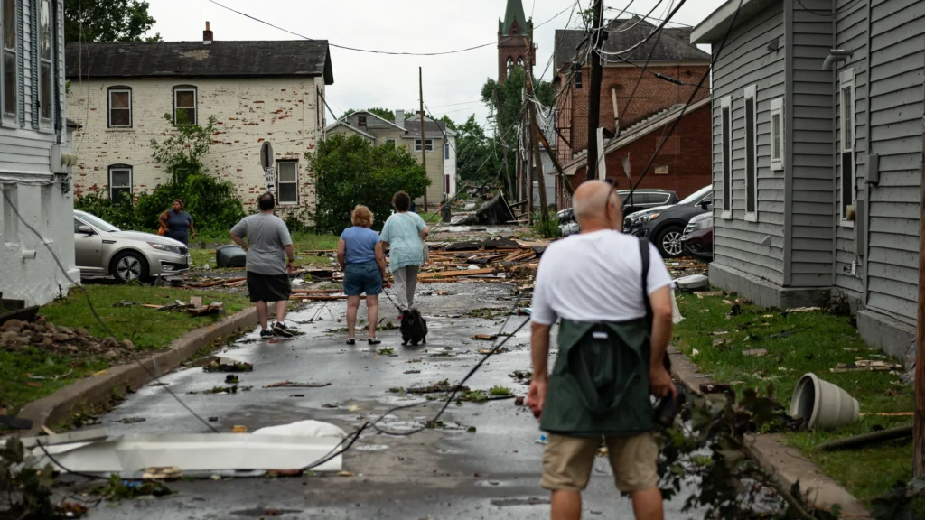
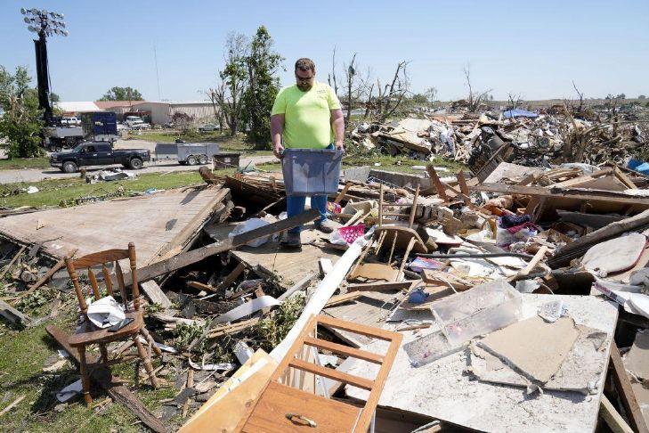
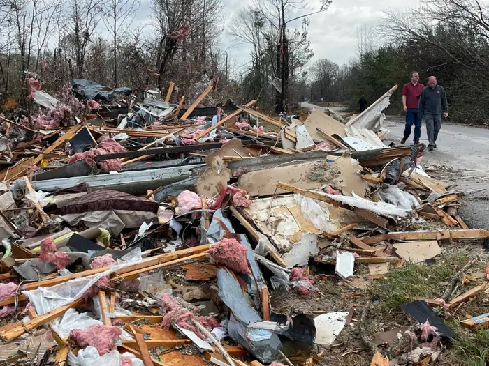
Bennett/Watkins Area Damage Assessment
A devastating tornado has left a trail of destruction in the Bennett and Watkins areas, east of Denver. The storm’s impact has been severe, with reports indicating significant damage to both residential and commercial properties.

Structural Damage Reports
The tornado’s fury has resulted in considerable structural damage. Homes and businesses in the affected areas have been severely impacted.
Residential Impact
A home located one mile west of Bennett has been confirmed damaged in the storm. Residents in the area are dealing with the aftermath, with many assessing the damage to their properties.
Commercial Property Damage
Local businesses have also suffered, with reports indicating damage to commercial properties. The full extent of the damage is still being assessed.
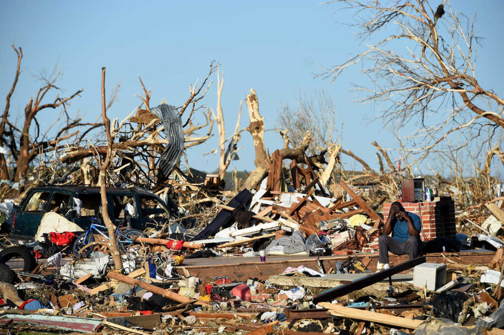
Injury Reports and Emergency Response
Emergency services are on the scene, responding to injury reports and assessing the situation. The response efforts are ongoing, with a focus on providing assistance to those affected.
CORE Electric Cooperative is reporting over 500 customers without power in Adams County, while Xcel Energy has reported over 100 outages in the Snyder, Weldona area. Utility companies are working to restore electricity as quickly as possible.
| Utility Company | Area Affected | Number of Outages |
|---|---|---|
| CORE Electric Cooperative | Adams County | 500+ |
| Xcel Energy | Snyder, Weldona | 100+ |
Local Authority Statements
Local authorities have made statements regarding the severity of the damage and the ongoing response efforts. According to a local official, “The situation is being closely monitored, and we are doing everything possible to support those affected.”
“The community has come together to support each other during this difficult time. We appreciate the efforts of the emergency responders and utility companies working to restore services.”
The Bennett and Watkins areas are dealing with the aftermath of the tornado, with a focus on recovery and rebuilding. The community’s resilience is being tested, but with support from local authorities and utility companies, they are working towards recovery.
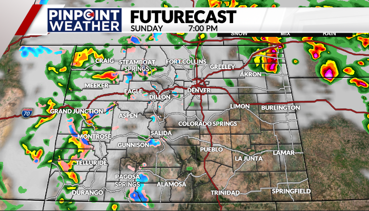
Denver Metro Weather Forecast
A dynamic weather system is moving into the Denver metro area, bringing with it a mix of rain, hail, and potentially damaging winds. While the metro area may avoid the worst of the severe weather, the eastern parts of Denver are expected to face significant storms.
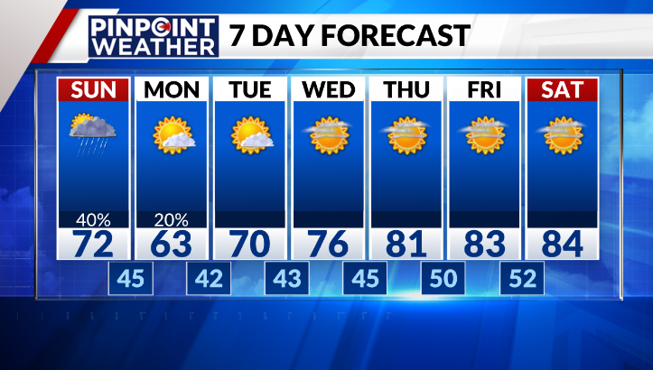
Today’s Storm Outlook
The Denver area is anticipated to experience rain showers and thunderstorms between 2 and 9 p.m. Sunday. The severe weather threats are expected to be more pronounced east of Denver, where hail and wind are the primary concerns.
Severe Weather East of Denver
Residents east of Denver should be prepared for potentially damaging hail and strong winds. The storms in this area are expected to be the most intense.
Metro Area Conditions
While the metro area is out of range for the worst severe weather threats, it’s still likely to experience rain and thunderstorms. Residents should remain vigilant and monitor the weather closely.
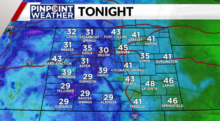
Tonight’s Weather Conditions
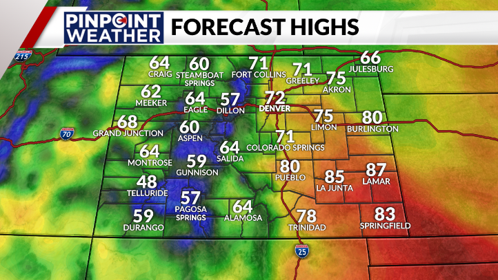
As the storms progress into the evening, they are expected to dissipate by 8 PM, leaving behind breezy conditions with gusts up to 25 mph and cooler temperatures in the mid-40s.
Storm Dissipation Timeline
The storms are forecast to dissipate by 8 PM, marking the end of the severe weather threat for the day.
Wind and Temperature Forecast
Following the storms, the area can expect breezy conditions and a drop in temperature, with lows in the mid-40s.
Extended Forecast for the Coming Week
Looking ahead to the coming week, Denver is expected to experience cooler temperatures, with highs in the 60s and dry conditions, except for a possible stray shower on Monday.
Road Closures and Transportation Impacts
Commuters in Denver are facing challenges due to the tornado’s impact on roads. The severe weather has significantly affected transportation in the area, with several road closures reported.
I-70 Status Updates
Traffic cameras showed what appeared to be a tornado crossing I-70, causing disruptions to the highway. Travelers are advised to check for the latest updates on road closures before heading out.

Alternative Routes for Commuters
To minimize disruptions, commuters are encouraged to explore alternative routes. Some of the recommended detours include:
- Taking US-85 instead of I-70
- Using CO-83 as an alternative route
- Avoiding the Bennett/Watkins area
Public Transportation Adjustments
Public transportation has also been affected, with adjustments made to bus routes and light rail operations.
Bus Route Changes
Several bus routes have been altered to avoid the affected areas. Passengers are advised to check the latest schedules.
Light Rail Operations
Light rail services have been temporarily suspended in some areas. Updates on service resumption will be provided as soon as possible.
Staying informed about the latest transportation updates is crucial for commuters to plan their journeys effectively.
Tornado Safety and Preparedness Guidelines
Tornado safety and preparedness are key to minimizing damage and injury during severe weather conditions in Denver and surrounding areas. Understanding the necessary precautions can significantly reduce the risk to life and property.
What to Do During a Tornado Warning
When a tornado warning is issued for your area, immediate action is necessary. The National Weather Service advises that “Flying debris may be deadly to those caught without shelter. Mobile homes will be damaged or destroyed. Damage to roofs, windows, and vehicles will occur. Tree damage is likely.”
Home Safety Procedures
If you’re at home, quickly move to a pre-designated shelter area, such as a basement or storm cellar. If no underground shelter is available, go to an interior room or hallway on the lowest floor, away from windows and doors. Get under a sturdy table or desk and cover your head and neck with your arms.
Vehicle Safety Measures
If you’re driving and a tornado is approaching, do not try to outrun it. Instead, leave your vehicle and seek shelter in a nearby building or lie flat in a low-lying area, such as a ditch or depression, and cover your head with your hands.
Creating a Family Emergency Plan
Having a well-thought-out family emergency plan is crucial. This plan should include where to meet if you get separated, how to stay in contact, and what to do in case of a tornado warning. Practice this plan with all family members to ensure everyone knows what to do.
Emergency Supply Kit Recommendations
An emergency supply kit should include essential items such as water, non-perishable food, a first aid kit, flashlights, and a battery-powered radio. The kit should be easily accessible and checked regularly to ensure all items are still usable.
| Item | Quantity | Notes |
|---|---|---|
| Water | At least 3 gallons per person | Stored in clean, airtight containers |
| Non-perishable food | Enough for 3 days | Include a manual can opener |
| First aid kit | 1 per household | Include bandages, antiseptic wipes, pain relievers |
“Preparation is key to surviving severe weather events. By having a plan and the necessary supplies, you can significantly reduce the risks associated with tornadoes.”
Community Response and Resources for Affected Residents
The aftermath of the Colorado tornado has seen a significant community response, with various resources available to affected residents. The local government and emergency management agencies are working together to provide support to those impacted by the Denver storm damage.
Emergency Shelter Locations
Residents who have been displaced due to the tornado can find shelter at designated locations. These emergency shelters are equipped with basic necessities and provide a safe haven for those in need.
Assistance Programs Available
Several assistance programs are available to help residents recover from the Denver tornado. These programs include financial aid, construction assistance, and other forms of support.
How to Report Damage
Residents are advised to report damage to their properties to the relevant authorities. This can be done through local government resources and emergency management agencies.
When reporting damage, residents should also initiate the process of filing insurance claims. Guidance on how to navigate this process is available through local government resources and insurance providers.
Local Government Resources
Local government resources are available to support recovery efforts. Residents can access information on assistance programs, emergency shelter locations, and other forms of support through these resources.
Tracking the Denver Tornado: Resources for Residents
For those affected by the Denver tornado, staying informed is crucial, and there are several resources to help. Residents can rely on real-time updates and emergency alerts to navigate this severe weather event.
Real-Time Radar Links
To track the Denver tornado effectively, residents can utilize real-time radar links from reputable sources.
NOAA Weather Radar
The NOAA Weather Radar provides comprehensive and up-to-date information on the storm’s progression.
KDVR Weather Tools
KDVR Weather Tools offer detailed insights into the tornado’s path and intensity, helping residents stay ahead of the storm.
Emergency Alert Systems
Emergency alert systems play a vital role in disseminating critical information during severe weather events. These systems ensure that residents receive timely warnings and updates.
Reliable Weather Information Sources
Reliable information is key to staying safe during a tornado. Residents can depend on official weather service channels and local news coverage for accurate updates.
Official Weather Service Channels
The National Weather Service provides authoritative forecasts and warnings, helping residents make informed decisions.
Local News Coverage
Local news channels offer detailed coverage of the storm, including road closures and emergency response efforts.
By leveraging these resources, residents can stay informed and take necessary precautions to ensure their safety during the Denver tornado.
| Resource | Description | Usefulness |
|---|---|---|
| NOAA Weather Radar | Real-time radar updates | High |
| KDVR Weather Tools | Detailed storm tracking | High |
| Emergency Alert Systems | Timely warnings and updates | Critical |
| Official Weather Service Channels | Authoritative forecasts | High |
| Local News Coverage | Detailed storm coverage | High |
Conclusion: Staying Safe During Severe Weather Events
As the severe weather event continues to unfold in Denver, it is essential for residents to stay safe and informed about the denver weather. The recent tornado denver incident has highlighted the importance of preparedness and staying updated with the latest information on colorado tornado today.
By understanding the risks associated with such events and following safety guidelines, the public can minimize the impact of the storm. Residents are advised to stay tuned to reliable weather information sources and follow emergency alert systems to stay ahead of the severe weather conditions.
Staying informed and being prepared are key to navigating challenging weather situations like the recent tornado denver incident. By staying vigilant and following safety tips, residents can ensure their safety and the safety of those around them.
FAQ
What is the current weather situation in Denver and surrounding areas?
A powerful storm system has brought severe weather to Colorado, with a reported tornado near Bennett and Watkins along I-70 east of Denver. Residents are advised to be cautious of large hail and damaging winds.
What are the latest updates on the tornado watch issued by the Storm Prediction Center?
The Storm Prediction Center has issued a tornado watch for southwestern Kansas and western Oklahoma, indicating a potential for EF3 or stronger tornadoes. The northeastern plains of Colorado are under a Level 3/5 risk for severe weather.
How can I stay informed about the progression of the severe weather event?
Residents can stay informed through real-time radar links from NOAA and KDVR, emergency alert systems, and official weather service channels. Local news coverage also provides timely updates and information.
What should I do during a tornado warning?
During a tornado warning, residents should seek shelter in safe locations, such as basements or storm cellars. If no underground shelter is available, go to an interior room or hallway on the lowest floor, away from windows and doors.
What are the emergency shelter locations for those affected by the severe weather?
Emergency shelter locations have been identified for residents affected by the severe weather. Information on these locations can be found through local government resources and emergency management websites.
How can I report damage from the tornado?
Residents can report damage to their local authorities and file insurance claims as needed. Local government resources are available to support recovery efforts.
What is the current status of I-70 and other transportation routes?
I-70 has been affected by the tornado, with reports of a tornado crossing the highway. Commuters are advised to check for updates on road closures and explore alternative routes. Public transportation has also been adjusted, with changes to bus routes and light rail operations.
How can I prepare for future severe weather events?
Residents can prepare by creating a family emergency plan, having an emergency supply kit, and staying informed about weather conditions. The National Weather Service and other weather services provide critical guidance on safety procedures.
What is the extended forecast for the Denver area?
The extended forecast suggests a cooler week ahead, with dry conditions except for a possible stray shower on Monday. Residents can expect breezy conditions and cooler temperatures following the severe weather event.


