


Multiday Severe Weather Threat: Tracking Dangerous Storms Across Midwest and Plains
A significant multiday severe weather threat is unfolding across the Midwest and Plains through early next week. Millions of residents from Minneapolis to Chicago, Milwaukee, and beyond face the risk of powerful storms capable of producing strong tornadoes, very large hail, and damaging hurricane-force winds. This comprehensive guide provides real-time tracking resources, safety information, and expert forecasts to help you stay ahead of these dangerous storms.

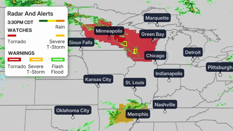
Current Severe Weather Situation

As of Thursday afternoon, a Tornado Watch is in effect for central Minnesota and western Wisconsin, including Minneapolis, through the evening hours. Several confirmed tornadoes have already been reported in Swift County, Minnesota, where a barn and part of a home were destroyed. Reports of a rotating wall cloud prompted a tornado warning for downtown Minneapolis and northern suburbs, with pea-sized hail reported in Rogers.
Track Storms In Real-Time
Don’t risk being caught unprepared. Access live radar, watches, and warnings to track these dangerous storms as they develop.
VIEW LIVE RADAR NOWThursday’s Severe Storm Threat

More than 89 million people from the Upper Midwest to the mid-Atlantic are at risk of severe weather today. The Storm Prediction Center has placed over 23 million people under a Level 3 out of 5 risk, including Chicago, Milwaukee, Madison, and Fort Wayne. Minneapolis, Detroit, and Indianapolis are under a Level 2 risk.
Tornado Risk
The greatest tornado threat extends from eastern Minnesota through Wisconsin into northern Illinois and Indiana. Some tornadoes could be strong (EF-2 or greater damage). Chicago and Milwaukee face the highest risk of tornado activity this evening.
Large Hail & Wind Threat
Hail the size of golf balls or larger is possible, particularly in the Level 3 risk area. Damaging straight-line winds could reach hurricane force (75+ mph) in some areas, capable of downing trees and power lines.
Friday’s Escalating Threat

The severe weather threat intensifies on Friday as the system shifts eastward. An outbreak of severe storms is possible in the Ohio and mid-Mississippi valleys, with more than 6 million people in cities like St. Louis, Louisville, Cincinnati, and Nashville under a Level 4 out of 5 risk.
FRIDAY SEVERE THREAT HIGHLIGHTS: Widespread damaging winds capable of downing many trees and knocking out power will be a particular concern from southeast Missouri to southern Illinois, southern Indiana, and western and central Kentucky. Some tornadoes could be strong (EF-2+), and hail larger than golf balls is expected.
Sign Up For Severe Weather Alerts
Receive immediate notifications when severe weather threatens your area. These critical minutes of warning could save lives.
GET WEATHER ALERTSWeekend Through Early Next Week Forecast

Saturday
Scattered severe storms could impact parts of the East, from New York state to North Carolina, as well as parts of the South, particularly Texas, Oklahoma, and Arkansas.
Sunday-Monday
The biggest threat shifts into the Central and Southern Plains, particularly from Kansas into Oklahoma and northern Texas. Dallas-Fort Worth, Oklahoma City, and Wichita should prepare for significant tornado threats.
Tuesday
Severe weather may shift eastward toward the Ark-La-Tex region and mid-Mississippi Valley with continued tornado, hail, and wind threats.
There is potential for an outbreak of severe thunderstorms on one or more days from Sunday through Tuesday. The combination of a southward plunge in the jet stream and warm, humid air streaming northward from the Gulf creates ideal conditions for severe storm development.
Tornado Safety Essentials

If You Have a Basement
- Go to the lowest level, preferably underground
- Stay away from windows
- Get under a sturdy piece of furniture
- Cover yourself with blankets or a mattress
If You Don’t Have a Basement
- Go to the lowest floor in an interior room
- Bathrooms, closets, or hallways away from exterior walls
- Cover yourself with blankets or a mattress
- Mobile home residents should seek sturdier shelter
Prepare Your Emergency Kit Now
Don’t wait until storms are approaching. Ensure you have essential supplies ready for when severe weather strikes.
GET EMERGENCY KIT CHECKLISTUnderstanding Weather Watches vs. Warnings

Tornado Watch
A Tornado Watch means conditions are favorable for tornadoes to develop. Stay alert, monitor weather reports, and be prepared to take shelter quickly if conditions worsen. Have your emergency plan ready.
Tornado Warning
A Tornado Warning means a tornado has been spotted or indicated by radar. Take shelter immediately! This is an emergency situation requiring immediate action to protect life and property.
Why This Multiday Severe Weather Threat Is Developing

A pair of southward plunges in the jet stream are carving into the western United States, then spreading toward the central states. One is arriving now, with another following this weekend into early next week. This pattern allows warm, humid air to stream northward from the Gulf of Mexico into the Plains and Midwest under an active jet stream.
This setup creates ideal conditions for severe thunderstorms, with the necessary ingredients of moisture, instability, and lift coming together. May is typically when tornado activity reaches its peak in the Plains and Midwest regions, making this pattern particularly concerning.
Essential Storm Tracking Resources

National Weather Service
Official government forecasts, warnings, and radar from NOAA’s National Weather Service.
Storm Prediction Center
Specialized forecasts for severe thunderstorms and tornadoes from NOAA’s Storm Prediction Center.
Local TV Weather
Your local TV meteorologists provide area-specific forecasts and live coverage during severe weather.
Download Weather Apps For On-The-Go Alerts
Stay informed wherever you are with these essential weather apps that provide real-time alerts and radar.
Staying Safe Through This Multiday Severe Weather Threat
This multiday severe weather threat represents a significant risk to millions of people across the Midwest and Plains through early next week. The combination of tornadoes, large hail, and damaging winds makes this a particularly dangerous situation that requires vigilance and preparation.
Remember that weather forecasts can change rapidly. Check back regularly for the latest updates, have multiple ways to receive warnings, and ensure your emergency plan is ready. Taking these precautions now could make all the difference when severe weather strikes.
Be Prepared, Not Scared
Knowledge and preparation are your best defenses against severe weather. Access these resources now to protect yourself and your loved ones.
COMPLETE SEVERE WEATHER PREPAREDNESS GUIDE


