


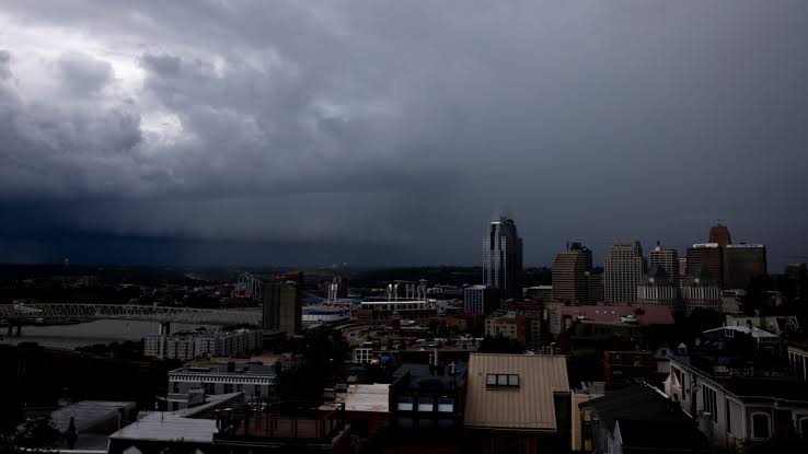

A Severe Thunderstorm Watch is currently in effect across Northeast Ohio until 7 p.m., as reported by the National Weather Service. Residents are advised to stay alert and prepared for the approaching storms.

The National Weather Service has issued a Severe Thunderstorm Warning for several parts of the region, indicating a potential threat to people and property. It is crucial for residents to take necessary precautions and stay informed about the latest weather updates.
A First Alert Weather Day has been designated, emphasizing the need for vigilance and preparedness. Stay safe by staying informed and following the guidance of local authorities.
Key Takeaways
- Severe Thunderstorm Watch is in effect across Northeast Ohio until 7 p.m.
- National Weather Service has issued a Severe Thunderstorm Warning for several parts of the region.
- First Alert Weather Day has been designated.
- Residents are advised to stay alert and prepared for the approaching storms.
- Stay informed about the latest weather updates.
- Follow the guidance of local authorities to stay safe.
Current Severe Thunderstorm Warning for Northeast Ohio
The National Weather Service has issued a severe thunderstorm warning for several counties in Northeast Ohio. This warning includes Cuyahoga, Geauga, Lake, Lorain, Medina, Portage, and Summit counties, indicating a significant threat from the approaching storms.
Residents in these areas should be prepared for potentially damaging winds, large hail, and frequent lightning. The severe thunderstorm warning signifies that the storms have the potential to cause significant damage and pose a risk to life.
The affected areas can expect wind gusts of up to 60 mph and hail stones as large as one inch in diameter. It is crucial for residents to stay informed through local news and weather reports for the latest updates on the storm’s progression.
Affected Counties and Precautions
| County | Main Threats | Recommended Actions |
|---|---|---|
| Cuyahoga | Damaging winds, large hail | Stay indoors, avoid travel |
| Geauga | Frequent lightning, wind gusts | Unplug electronics, stay away from windows |
| Lake | Large hail, heavy rain | Avoid driving, keep phone charged |
| Lorain | Damaging winds, lightning | Stay tuned to local news, have a safety plan |
| Medina | Wind gusts, hail | Secure outdoor furniture, stay indoors |
| Portage | Frequent lightning, heavy rain | Avoid being in open areas, keep a weather radio handy |
| Summit | Damaging winds, large hail | Stay informed, follow evacuation instructions if necessary |
It is essential for residents to remain vigilant and follow the instructions from local authorities to ensure their safety during this severe weather event.
National Weather Service Alert Details
A Severe Thunderstorm Warning has been issued for Northeast Ohio by the National Weather Service, signaling potentially dangerous weather conditions. This warning indicates that severe thunderstorms are imminent or already occurring in the region.
The National Weather Service issues Severe Thunderstorm Warnings when specific criteria are met, indicating a significant threat to the area. Understanding these criteria and the expected duration of the warnings is crucial for residents to take necessary precautions.
Warning Criteria and Thresholds
The criteria for a Severe Thunderstorm Warning include wind gusts of 58 mph or higher and/or hail that is one inch or larger in diameter. These conditions can cause significant damage to property and pose a risk to life.
The National Weather Service uses advanced radar and reporting systems to determine when these thresholds are met, ensuring timely warnings for affected areas.
Expected Duration of Warnings
Severe Thunderstorm Warnings are typically issued for a specific duration, usually between 30 minutes to an hour, depending on the storm’s progression and severity. The warning for Northeast Ohio is in effect until 7 p.m., as indicated by the current Severe Thunderstorm Watch.
Residents should stay tuned to local news and weather reports for updates on the warning’s status and any changes to the expected duration.
First Alert Weather Day: What It Means
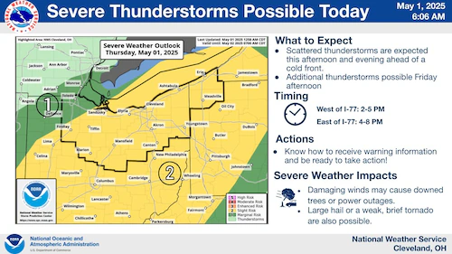
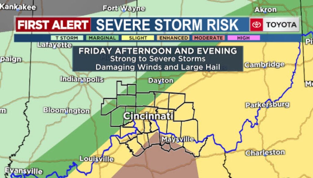
Northeast Ohio is bracing for severe storms, with Friday being designated as a First Alert Weather Day due to the risk of severe thunderstorms. A First Alert Weather Day is a critical designation that signifies a heightened risk of severe weather, necessitating immediate attention and action from the public.
The First Alert Weather Day designation is not taken lightly; it indicates that the weather conditions have the potential to be hazardous, impacting daily activities and potentially causing damage.
Significance of the First Alert Designation
The significance of a First Alert Weather Day lies in its ability to alert residents of potential severe weather conditions, allowing them to take necessary precautions. This designation is based on careful analysis of weather data and forecasting models, indicating a high likelihood of severe weather events such as thunderstorms, strong winds, and potentially tornadoes.
Key aspects of the First Alert designation include:
- Enhanced monitoring of weather conditions
- Timely updates and alerts to the public
- Preparation for potential emergencies
How First Alert Differs from Regular Forecasts
A First Alert Weather Day differs significantly from regular weather forecasts in its level of urgency and the specific actions recommended to the public. While regular forecasts provide general weather conditions and predictions, a First Alert Weather Day indicates a heightened state of awareness and readiness.
The table below highlights the main differences between a regular forecast and a First Alert Weather Day:
| Characteristics | Regular Forecast | First Alert Weather Day |
|---|---|---|
| Level of Urgency | General information | High urgency |
| Recommended Actions | General preparedness | Specific safety measures |
| Weather Conditions | General weather predictions | Severe weather expected |
Understanding the implications of a First Alert Weather Day is crucial for the safety and well-being of Northeast Ohio residents. By staying informed and taking recommended precautions, residents can minimize risks associated with severe weather events.
Severe Thunderstorm Warning NE Ohio: Understanding the Threat
Severe thunderstorms pose significant threats to Northeast Ohio, including wind damage, hail, and lightning. As these storms approach, understanding the potential dangers is crucial for residents to prepare and stay safe.
Wind Damage Potential
The wind damage potential from severe thunderstorms in Northeast Ohio should not be underestimated. Wind gusts can reach speeds that can knock down trees, damage roofs, and disrupt power lines. Residents are advised to secure outdoor furniture and decorations to prevent them from becoming projectiles in strong winds.
Hail Forecasts
Hail is another significant threat during severe thunderstorms. Hail forecasts indicate the potential size and intensity of hail, which can damage vehicles, roofs, and crops. Keeping an eye on hail forecasts can help residents take necessary precautions to protect their property.
Lightning Risks
Lightning is a deadly aspect of thunderstorms. The risk of lightning strikes increases during severe thunderstorms, posing a significant threat to people outdoors or in structures that are not lightning-safe. Understanding lightning risks and taking appropriate safety measures, such as seeking shelter in a substantial building or a hard-topped vehicle, is crucial.
To stay safe during severe thunderstorms, residents can follow thunderstorm safety tips such as staying indoors, avoiding conductive objects, and keeping away from windows. Utilizing live weather radar Ohio resources can also help in tracking the storm’s progression and making informed decisions.
By understanding the threats posed by severe thunderstorms and taking proactive measures, residents of Northeast Ohio can minimize risks and stay safe until the storm passes.
Affected Areas in Northeast Ohio
Northeast Ohio is bracing for severe thunderstorms, with multiple regions under warning, notably Cleveland, Akron, and surrounding areas. The severe thunderstorm warning has been issued for several counties, including Cuyahoga, Geauga, Lake, Lorain, Medina, Portage, and Summit.
Cleveland and Surrounding Counties
The Cleveland area, including Cuyahoga County, is directly in the path of the severe thunderstorms. Residents are advised to stay informed about the latest weather updates and to take necessary precautions to ensure their safety.
Affected Counties: Cuyahoga, Lake, Lorain
Akron-Canton Region Impact
The Akron-Canton region, encompassing Summit and surrounding counties, is also under the severe thunderstorm warning. This area can expect potentially damaging winds, large hail, and frequent lightning.
Preparation is key for residents in these areas to mitigate the impact of the storms.
Other Impacted Communities
Beyond Cleveland and Akron-Canton, other communities in Northeast Ohio are also affected. These include areas in Geauga, Medina, and Portage counties, where residents should be prepared for severe weather conditions.
| County | Main Cities | Expected Weather Conditions |
|---|---|---|
| Cuyahoga | Cleveland | Damaging winds, large hail, frequent lightning |
| Summit | Akron | Strong winds, hail, lightning |
| Lorain | Lorain, Elyria | Severe thunderstorms with wind damage potential |
| Geauga | Chardon | Heavy rain, hail, lightning |
| Portage | Kent, Ravenna | Strong winds, heavy rain |
Timeline of Storm Development and Progression
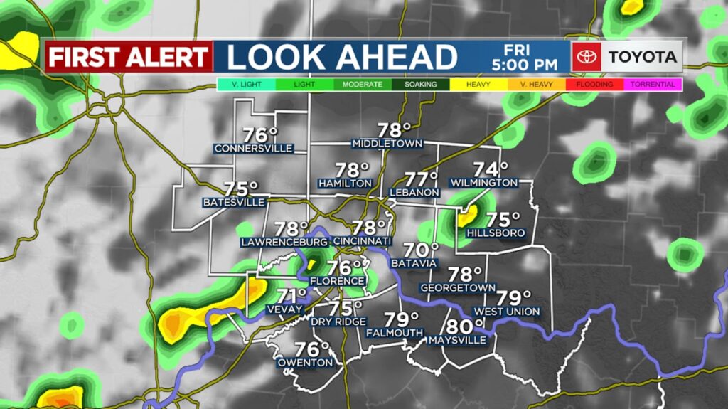
A powerful cold front is set to bring scattered showers and thunderstorms to the region this afternoon and evening. As the front moves across Northeast Ohio, the potential for severe weather will increase, making it crucial to stay updated with the latest severe weather updates today.
Storm Formation Factors
The development of thunderstorms is influenced by several factors, including the interaction between the cold front and the existing atmospheric conditions. Moisture from the previous days’ weather, combined with the cooler air from the front, creates a volatile mixture that can lead to intense thunderstorms.
Additionally, wind shear and the instability of the atmosphere play significant roles in determining the severity of the storms. Understanding these factors is key to predicting the Ohio thunderstorm watch 2024 conditions accurately.
Projected Path and Intensity Changes
According to the latest live weather radar Ohio data, the storm system is expected to move rapidly across the region. The path is predicted to cover a significant portion of Northeast Ohio, with the potential for heavy rain, hail, and damaging winds.
As the storm progresses, its intensity is expected to change, potentially weakening as it moves further into the region. However, the exact trajectory and intensity will depend on various atmospheric conditions, making it essential to monitor updates closely.
Ohio Thunderstorm Watch 2024: Season Context
The current Ohio thunderstorm watch is a significant event in the 2024 season’s severe weather landscape. As we navigate through the year, understanding the context of this watch is crucial for residents and visitors alike.
The risk of severe storms is highlighted for the current season, with severe thunderstorm watches being issued for areas like Northeast Ohio. This watch is part of a broader pattern of severe weather activity observed in 2024.
Comparison to Previous Years
Comparing the 2024 thunderstorm season to previous years reveals some interesting trends. Historically, Ohio experiences a significant number of thunderstorms during the spring and summer months. However, the frequency and intensity of these storms can vary greatly from year to year.
- Increased Frequency: Some years see a higher frequency of thunderstorms due to specific weather patterns.
- Enhanced Intensity: The intensity of these storms can also vary, with some years experiencing more severe weather events.
The 2024 season is notable for its severe thunderstorm watch issuances, indicating a potentially higher risk period for Ohio residents.
Seasonal Patterns and Predictions
Understanding the seasonal patterns of thunderstorms in Ohio is essential for predicting future severe weather events. Typically, the spring and early summer months are the most active for severe thunderstorms.
- Weather patterns such as the jet stream and temperature gradients play a significant role in determining the severity of thunderstorm seasons.
- Long-term climate trends can also influence the frequency and intensity of thunderstorms.
By analyzing these patterns, meteorologists can provide more accurate predictions and warnings, helping the public prepare for potential severe weather events.
The Ohio thunderstorm watch 2024 is a critical alert for residents, signaling the need for vigilance and preparedness. By staying informed about weather conditions and understanding the context of the current thunderstorm watch, individuals can take necessary precautions to ensure their safety.
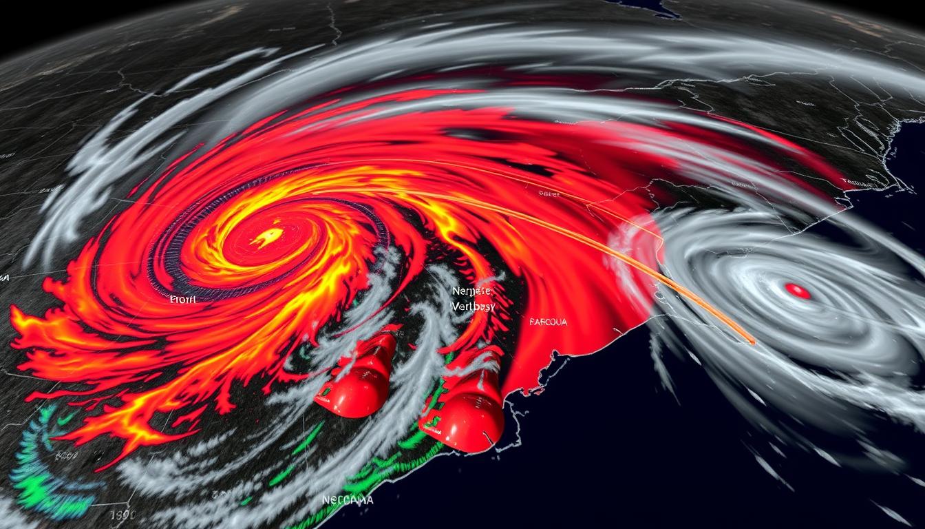
Live Weather Radar Interpretation
To stay ahead of severe weather, it’s essential to know how to read live weather radar imagery. Live weather radar is a critical tool for tracking storms and understanding their potential impact.
Understanding Radar Colors and Patterns
Radar colors and patterns provide crucial information about the intensity and type of precipitation. For instance, green typically indicates light precipitation, while red signifies heavy precipitation.
A detailed understanding of these colors and patterns can help residents in Northeast Ohio prepare for potential severe weather events.
Storm Movement Predictions
Predicting storm movement involves analyzing the direction and speed of storm systems. This information is vital for issuing timely severe thunderstorm warnings.
| Storm Characteristic | Radar Indicator | Implication |
|---|---|---|
| Storm Speed | Movement vectors | Faster storms may catch residents off guard if not monitored closely. |
| Storm Intensity | Color intensity (e.g., red for heavy rain) | Higher intensity storms pose greater risks, including hail and damaging winds. |
| Storm Direction | Radar loop showing storm path | Understanding direction helps in preparing for the storm’s impact. |
For the latest updates on live weather radar Ohio and severe thunderstorm warnings, download the First Alert Weather App.
Digital Tools for Tracking Severe Weather
In the age of smartphones and instant information, tracking severe weather has become more accessible than ever. With numerous digital tools at your disposal, staying informed about severe weather updates today is easier and more efficient.
To effectively track and prepare for severe weather, it’s essential to leverage the right digital tools. Here are some of the most useful resources:
Recommended Weather Apps
Weather apps have revolutionized how we stay informed about weather conditions. Some of the top recommendations include:
- First Alert Weather App: Known for its accuracy and user-friendly interface, this app provides real-time updates and severe weather alerts.
- The Weather Channel App: Offers comprehensive weather forecasts, radar imagery, and severe weather alerts.
- Dark Sky: Provides hyperlocal weather forecasts and alerts, making it ideal for minute-by-minute updates.
Social Media and Alert Systems
Besides dedicated weather apps, social media and alert systems play a crucial role in disseminating severe weather information. Following local news stations, weather services, and emergency management agencies on platforms like Twitter and Facebook can provide timely updates. Additionally, signing up for emergency alerts from local authorities ensures you receive critical information directly to your phone.
Some key benefits of using these digital tools include:
- Real-time Updates: Get the latest information as the weather situation develops.
- Customizable Alerts: Many apps allow you to tailor alerts based on your location and the type of weather event.
- Enhanced Safety: By staying informed, you can take necessary precautions to ensure your safety and the safety of those around you.
By utilizing these digital tools, residents in Northeast Ohio can stay ahead of severe weather events, such as those associated with a First Alert Weather Day or a Cleveland severe weather alert. Stay informed, stay safe.
Difference Between Watches and Warnings
The National Weather Service issues two critical alerts for severe thunderstorms: watches and warnings, each requiring different responses. Understanding these alerts is vital for residents in Northeast Ohio to stay safe during severe weather events.
What Triggers Each Alert Level
A severe thunderstorm watch is issued when conditions are favorable for severe thunderstorms to develop. This means that the atmospheric conditions are ripe for storms that could produce damaging winds, large hail, or tornadoes.
On the other hand, a severe thunderstorm warning is issued when a severe thunderstorm is imminent or already occurring. This warning signifies that the storm is capable of producing significant damage and poses a direct threat to life and property.
| Alert Level | Trigger | Implication |
|---|---|---|
| Watch | Conditions favorable for severe thunderstorms | Be prepared for severe weather |
| Warning | Severe thunderstorm is imminent or occurring | Take immediate action to ensure safety |
Appropriate Responses to Each
During a severe thunderstorm watch, residents should remain vigilant and be prepared to take action if necessary. This includes staying informed about the latest weather forecasts and having a plan in place in case the situation escalates.
When a severe thunderstorm warning is issued, immediate action is required. Residents should seek shelter in a safe location, such as a basement or interior room on the lowest floor, and stay away from windows and doors.
By understanding the difference between a watch and a warning, and by taking appropriate actions, residents in Northeast Ohio can minimize risks associated with severe thunderstorms and stay safe until the weather improves.
Thunderstorm Safety Tips for Residents
With storms approaching Northeast Ohio, understanding thunderstorm safety tips is crucial for residents. A few storms may turn severe, producing damaging wind gusts, large hail, and heavy rain, making it essential to be prepared.
Indoor Safety Measures
When a severe thunderstorm warning is issued for Northeast Ohio, staying indoors is the safest option. Ensure that you are in a sturdy building, away from windows and doors. Unplug appliances and electronics to protect them from power surges.
- Stay away from windows and exterior walls.
- Avoid using water during the storm to minimize the risk of electrical shock.
- Keep a battery-powered radio handy to stay informed.
Vehicle Safety During Storms
If you are driving when a severe thunderstorm hits, pull over and wait for the storm to pass. Keep your vehicle in a safe location, away from flood-prone areas.
- Avoid driving through flooded roads, as they can be deceptively dangerous.
- Keep your gas tank full to ensure you can keep your vehicle running if needed.
- Use low gear when driving in flooded areas to avoid stalling.
Outdoor Precautions
If you are outdoors when a thunderstorm approaches, quickly seek shelter in a sturdy building or a hard-topped vehicle. Avoid being in open areas or near tall objects that could attract lightning.
Avoid being near conductive objects like golf clubs or bicycles, and stay away from bodies of water. If you are in a group, spread out to prevent the risk of multiple injuries from a single lightning strike.
Potential Impact on Infrastructure
Northeast Ohio is bracing for potential infrastructure challenges as severe thunderstorms approach. The region’s infrastructure, including power grids and road networks, is expected to face significant stress due to the anticipated severe weather conditions.
Power Outage Preparations
Residents should prepare for potential power outages by having backup power sources, such as generators, and keeping essential supplies like flashlights and batteries handy. It’s also crucial to keep devices charged and have backup power banks available.
- Have a plan for alternative lighting and power sources.
- Keep your vehicle’s gas tank at least half full.
- Unplug sensitive electronics to protect them from power surges.
Road Safety Concerns
The severe thunderstorms may lead to hazardous road conditions, including flooding and debris. Drivers should exercise caution, avoid travel unless necessary, and keep an emergency kit in their vehicles.
Key Road Safety Tips:
- Avoid driving through flooded areas.
- Keep a safe distance from other vehicles.
- Be aware of downed power lines and avoid them.
By being prepared and staying informed, residents of Northeast Ohio can minimize the impact of the severe thunderstorms on their daily lives and infrastructure. Stay tuned to local weather alerts and follow the guidance of local authorities to stay safe during this Cleveland severe weather alert.
For the latest updates on the Akron Canton storm warning and other severe weather alerts, residents are advised to monitor local news and weather reports closely.
Emergency Resources and Contacts
When severe thunderstorms hit Northeast Ohio, having a list of emergency resources and contacts can be a lifesaver. Residents of Cleveland and Akron-Canton should be prepared with the necessary information to handle emergencies effectively.
For immediate assistance during severe weather, it’s crucial to know who to contact. Here are some key resources:
County Emergency Management Agencies
Each county has its own emergency management agency responsible for coordinating responses to emergencies. For Northeast Ohio, some of the key agencies include:
- Cuyahoga County Emergency Management: Provides emergency preparedness and response information.
- Summit County Emergency Management: Offers resources and guidance for emergency situations.
- Other counties, such as Lorain and Medina, also have their own emergency management agencies that provide vital services.
Utility Company Emergency Numbers
In case of power outages or other utility-related emergencies, having the contact numbers for utility companies is essential. Some of the major utility companies in Northeast Ohio include:
- FirstEnergy: 1-800-851-2345 for reporting power outages.
- Dominion Energy: 1-800-769-3766 for gas-related emergencies.
For the latest severe weather updates today, residents can check 19 News or visit the National Weather Service website. Staying informed and having the right contacts can significantly enhance safety during severe weather events.
To stay updated on Cleveland severe weather alerts and Akron Canton storm warnings, follow local news channels and sign up for emergency alerts from your county’s emergency management agency. Being prepared is key to navigating through severe weather conditions safely.
After the Storm: Damage Assessment and Reporting
Northeast Ohio residents can now begin assessing the damage caused by the recent severe thunderstorm warning. The aftermath of such storms often reveals the true extent of the impact on homes, businesses, and infrastructure.
Assessing and reporting damage is a crucial step in the recovery process. It not only helps individuals receive the necessary assistance but also aids in the overall community’s efforts to rebuild and recover.
How to Document Storm Damage
Documenting storm damage is essential for insurance claims and recovery efforts. Residents should take clear, well-lit photos of all damage, including structural issues to homes, vehicles, and other properties. It’s also advisable to make a detailed list of damaged items, including their approximate value and the date of purchase.
For property damage, it’s crucial to capture images of the exterior and interior, including roofs, walls, windows, and any affected personal belongings. For vehicles, document any dents, broken glass, or other damage.
When and How to Report Hazards
Reporting hazards is vital for ensuring public safety. Residents should report any hazards, such as downed power lines, fallen trees, or flooded roads, to the appropriate authorities immediately. For downed power lines, contact the utility company or emergency services. For other hazards, local government or county emergency management agencies can be contacted.
When reporting hazards, provide as much detail as possible, including the location and nature of the hazard. This information helps emergency responders prioritize their efforts and ensure a swift response.
By documenting damage and reporting hazards, Northeast Ohio residents play a critical role in the recovery process. Your efforts can be shared with 19 News, and you may see your contributions on TV or online.
Weather Forecast for the Coming Days
As Northeast Ohio continues to recover from the recent severe thunderstorms, the weather forecast for the coming days is shaping up to be quite eventful. Residents are advised to stay informed about the latest severe weather updates today to ensure their safety.
Saturday is expected to be generally cloudy with frequent showers throughout the day. This recovery period weather will be crucial in determining the overall impact of the recent storms on the region.
Recovery Period Weather
The recovery period weather is forecasted to be quite dynamic, with ongoing showers and potential for additional thunderstorms. It’s essential for residents to monitor the live weather radar Ohio to track the movement and intensity of these storms.
Frequent updates from local weather services will provide insights into the expected duration and intensity of the recovery period weather. This information will be vital for planning and safety measures.
Additional Storm Systems on the Horizon
Looking ahead to the next few days, there are indications of additional storm systems that could impact Northeast Ohio. The Ohio thunderstorm watch 2024 remains in effect, and residents are urged to stay vigilant.
Tracking these potential storms using live weather radar Ohio will be crucial. The ability to anticipate and prepare for these storms will significantly enhance safety and minimize disruptions.
Staying informed and prepared is key during this period. Residents are encouraged to follow reliable weather forecasts and emergency alerts to stay ahead of the weather.
Conclusion: Staying Vigilant During Severe Weather Season
As a severe thunderstorm warning NE Ohio is issued, residents must remain alert and prepared for the potential dangers associated with such weather conditions. Understanding the significance of a First Alert Weather Day and staying informed about the latest northeast Ohio weather alert can be crucial in ensuring safety.
To stay ahead of severe weather, rely on trusted sources like the First Alert Weather App and local news updates from 19 News. These resources provide timely updates and critical information to help you navigate through severe thunderstorm events.
By staying vigilant and informed, you can minimize risks and ensure your safety and the safety of those around you during severe weather season in Northeast Ohio.
FAQ
What is a Severe Thunderstorm Warning, and how does it differ from a watch?
A Severe Thunderstorm Warning is issued by the National Weather Service when a severe thunderstorm is imminent or already occurring, indicating a significant threat to life and property. It differs from a watch, which is issued when conditions are favorable for severe thunderstorms to develop.
What areas are affected by the Severe Thunderstorm Warning in Northeast Ohio?
The Severe Thunderstorm Warning affects several parts of Northeast Ohio, including Cleveland, Akron-Canton, and surrounding counties. Residents in these areas should take necessary precautions to stay safe.
How can I stay informed about the latest updates on the Severe Thunderstorm Warning?
You can stay informed through local news, the National Weather Service website, and recommended weather apps, such as those provided by the Weather Channel or AccuWeather, which offer real-time updates and alerts.
What are the potential threats associated with severe thunderstorms in Northeast Ohio?
Severe thunderstorms in Northeast Ohio can bring wind damage, hail, and lightning risks. Residents should be prepared for these hazards and take necessary safety precautions.
How can I interpret live weather radar imagery to predict storm movement?
Understanding radar colors and patterns can help predict storm movement. Generally, red or purple colors indicate heavy precipitation or severe weather, while green or yellow colors indicate lighter precipitation.
What safety measures should I take during a thunderstorm?
During a thunderstorm, stay indoors, avoid windows, and unplug electronics. If driving, pull over and stay in your vehicle with the windows closed. Avoid being outside, especially in open areas or near tall objects.
How can I prepare for potential power outages caused by severe thunderstorms?
To prepare for power outages, have flashlights, batteries, and a battery-powered radio on hand. Consider purchasing a portable generator, and keep your devices charged.
What should I do after the storm to assess and report damage?
After the storm, inspect your property for damage, take photos or videos for insurance purposes, and report any hazards to the authorities. Be cautious when exiting your home, as there may be fallen power lines or other dangers.
How can I stay updated on the weather forecast for the coming days?
You can check the latest weather forecast on local news, the National Weather Service website, or through recommended weather apps, which provide updates on the recovery period weather and any additional storm systems on the horizon.
What is a First Alert Weather Day, and how does it differ from regular forecasts?
A First Alert Weather Day is designated when there is a significant threat of severe weather, indicating that residents should be prepared and stay informed. It differs from regular forecasts in that it highlights a higher level of urgency and potential danger.
What are the emergency resources and contacts available in case of a severe thunderstorm?
County Emergency Management Agencies and utility company emergency numbers are available for residents to contact in case of emergencies or to report hazards.


